Best Backpacking GPS of 2026

A backpacking GPS has one job: keep you found when the trail gets vague or the weather turns. The worry is that it will fail exactly then—lose signal under heavy trees, freeze at a junction, or display a screen you cannot read in sun. I have had a handheld quit on a damp, cold morning, so I care less about feature lists and more about reliability when my hands are numb and my patience is thin. The right unit fixes that by making your position, route, and next turn obvious without fiddling.

Over nine months, we carried seven backpacking GPS units on the same local loops—through dense canopy, open ridge, and wet, cold mornings—and compared track logs for accuracy, screen size and behavior, and gloved-hand usability. What separated them was rarely the longest feature list. It was whether the map stayed readable in direct sun, whether the unit recovered quickly under trees, and whether the price felt fair for what you actually use. The picks below are the ones we trust when trail signs run out.

1

Best Overall

Garmin GPSMAP 65s

87 /100
Traveler Score Excellent

Key details

Maps
TopoActive + public land (U.S.)
Screen
2.6 in color
Battery Life
16 hours
Satellite Support
Multi-band GNSS
Check Details on Amazon

The GPSMAP 65s is the one we reach for when the route matters more than the pack weight. Its 2.6-inch sunlight-readable screen is the easiest of the handhelds here to follow while moving, and the multi-band GNSS receiver is built for steep country, dense canopy, and other challenging locations where a single satellite fix can wander. We also value the 3-axis compass and barometric altimeter: when we stop to check a bearing or confirm a climb, the answer is on the device instead of behind a phone unlock. At 7.68 ounces it is not the lightest pick, but that heft buys a steadier feel and a display that does not demand a squint.

The 16-hour battery rating is the first trade-off we noticed. That is plenty for a day hike, but on a multi-day route it means carrying spare batteries and being deliberate about screen time. The 65s takes removable batteries, which we prefer in the backcountry because a fresh set resets the clock without a wall outlet. Button controls are another good match for gloves and wet weather. Garmin's menus still take patience, and we spent time setting up routes and waypoints before trusting the screen on a complicated day. Once that is done, the navigation view is clear and the track is easy to follow.

The mapping is where the 65s justifies its bulk for backpacking. Preloaded TopoActive maps cover routable roads and trails, and the federal public-land layer (U.S. only) helps when a route crosses a boundary or a patchwork of ownership. There is 16 GB of internal memory plus a microSD slot, so a map update does not have to mean deleting something else. If you mostly walk marked trails and want the lightest carry, the eTrex 22x makes more sense. But when accuracy, a readable screen, and on-board sensors matter, the 65s is the one we pack first.

Pros

  • Multi-band GNSS for tight terrain
  • Readable 2.6-inch color screen
  • Compass and barometric altimeter
  • TopoActive maps and public-land data

Cons

  • 16-hour battery life needs spare cells
  • Menu system takes time to learn
Our verdict

We recommend the GPSMAP 65s for backpackers who want the most accurate, readable navigation screen here and can carry a little more weight.
Check Latest Price
2

Best Value

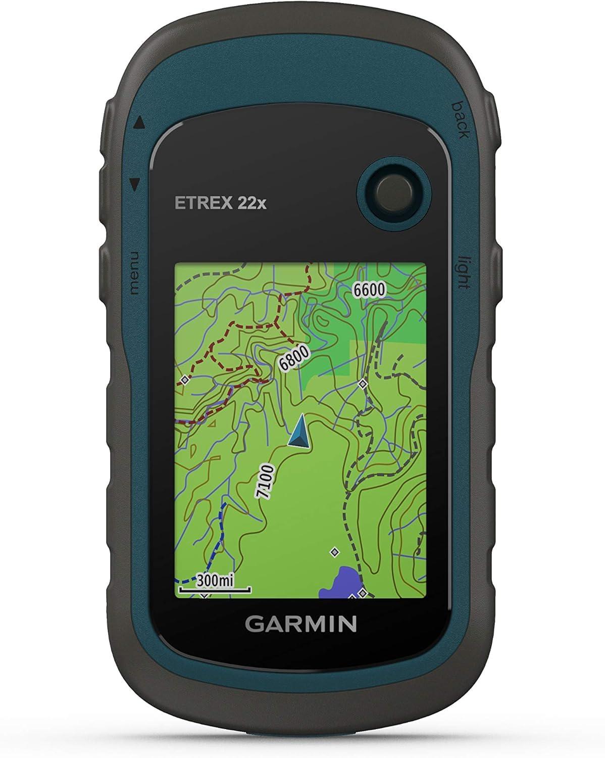
Garmin eTrex 22x

86 /100
Traveler Score Excellent

Key details

Maps
TopoActive
Weight
4.96 oz
Battery Life
25 hours
Satellite Support
GPS + GLONASS
Check Details on Amazon

At 4.96 ounces, the eTrex 22x is the one that disappears into a pack pocket until you need it. We think that lightness matters more on a backpacking GPS than a long feature list, and the 22x pairs it with 25 hours of listed battery life — enough for a long day and then some. The 2.2-inch color screen is small, no question, and the 240 x 320 resolution will not make anyone forget a phone. But it is sunlight-readable, and the button controls work when the screen is wet or your fingers are cold. For straightforward trail navigation, that is a sensible trade.

The 22x comes with preloaded TopoActive maps and support for GPS and GLONASS, plus 8 GB of internal memory and a microSD slot. We like that combination for backpacking because the map is already on the device; you are not relying on a cell signal at the trailhead. The catch is the learning curve. We found the menus busier than they need to be for basic waypoint and track work, and the small screen makes browsing them slower. If you mostly follow a planned track and check your position, it is manageable. If you want to build routes on the device while standing in the wind, budget extra patience.

Where the 22x earns its place is value and simplicity of carry. It costs less than the GPSMAP 65s, weighs less, and runs longer on its listed battery life, so it suits the backpacker who wants dependable offline navigation without paying for multi-band accuracy or a larger display. We do not think the screen or the menu system will win over anyone who wants a phone-like experience. But for keeping a route in view and a track recording, it does the core job at a weight you will not resent.

Pros

  • Light 4.96-ounce body
  • 25-hour battery life
  • Preloaded TopoActive maps
  • 8 GB memory plus microSD

Cons

  • Small 2.2-inch display
  • Busy menus take practice
Our verdict

We recommend the eTrex 22x for backpackers who want preloaded topo maps and long battery life in a light, affordable handheld.

Check Latest Price

How We Tested Backpacking GPS Units

We built a shortlist from current handheld GPS units that experienced backpackers actually carry, then narrowed it by map support, weather sealing, battery life, and price. Over nine months, seven units went on the same day hikes and two multi-day trips—through dense tree cover, along exposed ridges, and out on wet, cold mornings. Each unit was carried in a hip pocket or top-lid, turned on at the trailhead, and used to mark the same junctions, water sources, and campsites.

To check accuracy, we compared each unit's track log with the actual trail and with the others' logs, noting drift at switchbacks and whether distance totals matched the map. For reliability, we watched for dropped signals under canopy, slow satellite locks, frozen screens, and whether the unit recovered after being stowed in a hip pocket or caught in a brief rain shower. We also ran the same route in poor weather and noted any shutdowns, ghost waypoints, or menus that stalled when we needed them.

Usability was judged with bare hands and with liner gloves: how many button presses it took to mark a waypoint, how easily we could pan the map, and whether the menus made sense after a long day. We looked at screen size in relation to pocketability and checked screen quality in direct sun, shade, and rain, noting glare, contrast, and whether the display showed fingerprints or scratches too readily. Finally, we weighed value by matching each unit's price to the functions we truly used—not the ones buried in menus—and asked whether the build quality justified carrying it for years.

How to Choose Backpacking GPS

Start With Offline Topographic Maps

A handheld is only useful off-grid if the map is already on the device. Preloaded topographic maps such as TopoActive give you trails, roads, and contours without a phone signal; public-land boundaries are a bonus if you hike in the U.S. The GPSMAP 65s carries both, and the eTrex 22x carries TopoActive. A basemap or app-dependent map is not the same thing, so check what is installed before you buy. If a big update is coming, have a microSD card on hand; internal memory can fill up.

Match Satellite Support to the Terrain

GPS and GLONASS support is the basic standard here, and it is enough for open trails and ordinary forest cover. Multi-band GNSS, which the GPSMAP 65s lists, is worth paying for if you route-find in steep country, dense canopy, or canyon walls where a fix can bounce or fade. The eTrex 22x sticks with GPS and GLONASS, which is a reasonable match for straightforward backpacking. Think about where you actually walk rather than buying the longest satellite list; a clear-sky ridge does not need the same receiver as a shaded drainage.

Treat Battery Life as Trip Logistics

The listed runtime is a planning number, not a guarantee. The eTrex 22x lists 25 hours, while the GPSMAP 65s lists 16; on a multi-day trip, that difference decides how many spare cells you carry. Cold weather can pull runtime down, so keep batteries warm and start with fresh ones. We prefer removable batteries in a backpacking device because a fresh set resets the clock without a wall outlet. Count your expected hours, add a margin for navigation checks, and carry one more set than the math says.

Choose Controls and Screen for Cold, Wet Hands

A 2.2-inch screen like the eTrex 22x keeps the device pocketable, but it asks more of your eyes when you are moving. The GPSMAP 65s steps up to 2.6 inches and a more readable panel, which is why it suits route-finding on the go. Buttons beat touch in rain or gloves, and both picks use them. The trade is menu depth: Garmin's interface rewards a little setup at home. Build your routes and waypoints before the trip so you are not learning the menu on a windy ridge.

Weigh Sensors and Ounces Together

A 3-axis compass and barometric altimeter, both listed on the GPSMAP 65s, help when you stop to take a bearing or confirm elevation gain without moving. They add usefulness and weight: the 65s is 7.68 ounces, while the eTrex 22x is 4.96. That difference is noticeable at the end of a long day. If you navigate mostly by following a track and checking position, the lighter device is the smarter carry. If you use bearings and elevation as part of your route, the sensor-equipped model earns its bulk.

Frequently Asked Questions

Final Verdict

For most backpackers, we recommend the GPSMAP 65s. Its multi-band receiver, 2.6-inch screen, and on-board compass and altimeter make route-finding less fiddly in complicated terrain. It is the heavier, shorter-running choice, but it is the one we trust when navigation gets serious.

If weight and battery life matter more, the eTrex 22x is the better carry: it is lighter, runs longer on its listed battery, and still has TopoActive maps on board. Neither replaces a paper map and compass, but either makes a phone-free backup practical.